After long and illustrious service, SchoolDash Explorer has retired. We recommend using our new service, The Schools Guide. It contains all the features of SchoolDash Explorer and much, much more.
Welcome to SchoolDash Explorer! Whether you're looking for a suitable school for your child or investigating educational trends, we hope that it will help you to quickly understand the locations and characteristics of schools in England. If you have comments, corrections or other feedback then please send us an email.
Primary, secondary or sixth form
Use the drop-down menus at the top of the page to select the educational phase – primary, secondary or sixth-form – in which you're interested as well as the colours in which you would like the schools to appear on the map. If you choose 'blue', 'green' or 'red' then all relevant schools will appear in that colour, but you can also colour schools differently according to their characteristics. In the latter case a scale will appear next to the menu to show you which colours represent high and low values.

Types of school
Use the next row of checkboxes to include or exclude certain types of schools. For example, if your child is a girl then you may wish to exclude 'all-boys' schools, or you might have preferences regarding religious affiliation.
Finding a location
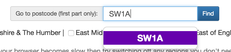
If you know the postcode of the area in which you're interested then enter the first part of it in the search box to be taken straight there. Alternatively, you can pan and zoom the map until you find the right area of the country. SchoolDash Explorer is built on Google Maps so the same controls apply (ie, pan by dragging the map, and zoom by double-clicking or using the +/- buttons at the bottom-right; on touch-screen devices you can also use pinch gestures).
Selecting regions
If you pan and zoom to an area then make sure that you also select one or more regions in order for the schools there to be displayed. Do this by using the second row of checkboxes. Depending on the speed of your computer, turning on a lot of regions might slow down your browser, so it's safest to use only the ones you need. If you use the postcode search then the appropriate region will be turned on automatically.
Maps
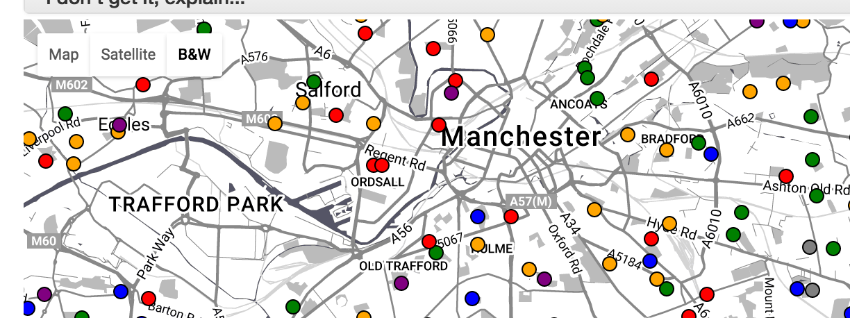
By default, a standard Google Map provided but you can also select satellite or black-and-white views using the buttons at the top-left of the map. The black-and-white view may sometimes make it easier to see the colours of the dots representing the schools.
School details
Hover your mouse over each dot to see the name of the school or click on any dot to see further details about the school, including key statistics. Percentage scores indicate the school's ranking in the latest year for which data are available (usually 2015). The higher the figure the better. For example, a score of 60% means that the schools is 60% of the way up the national list (ie, in the top 40%) when all schools are ranked in order.
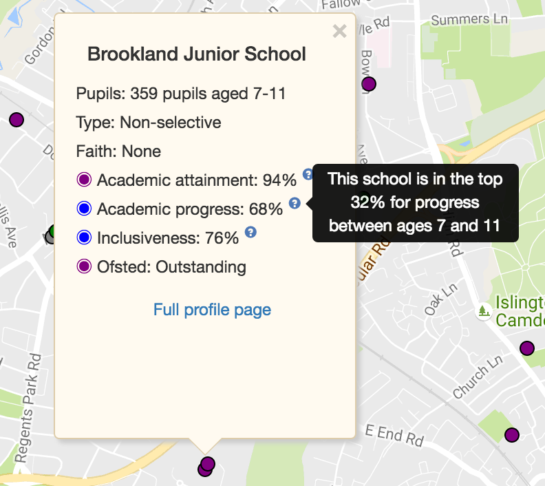
To explain each measure in a bit more detail:
- Academic attainment indicates the level of performance in school assessments, national tests or exams taken at ages 7, 11, 16 or 18 (as appropriate for the particular school and educational phase). As of 16th October 2017, attainment indicators for secondary schools use the newly released 2017 Attainment 8 statistics.
- Academic progress takes into account the ability of pupils coming into the school and uses a variety of 'progress' or 'value-added' measures calculated by the Department for Education. As of 16th October 2017, progress indicators for secondary schools use the newly released 2017 Progress 8 statistics. If a school shows poor attainment but good progress then it is a sign that the pupils entering the school are, on average, relatively low performers, but that they make substantial progress during their time there. Conversely, high attainment combined with low progress suggests that the school's academic success may be due to an able intake rather than particularly great teaching.
- Inclusiveness compares the proportion of poorer pupils at the school with the level of poverty in the surrounding neighbourhood (as measured in the 2011 census). This is based on our previous review of social selection in schools. As in that analysis, we have used a 2km radius to define the neighbourhood of each primary school and a 4km radius to defined the neighbourhood of each secondary school or sixth form.
- Ofsted rating reflects the conclusions of the national inspectors last time they visited the school (which may have been several years ago). There are four categories: Outstanding (purple), Good (green), Requires Improvement (orange) and Inadequate (red). Some 'Inadequate' schools have also been put into so-called 'special measures' to improve their performance, in which case this is noted.
A link is also provided to the full SchoolDash profile page of the school, which contains much more information.
Note that some schools include primary, secondary and/or sixth-form phases in the same institution. In these cases the academic performance and inclusiveness data displayed may vary depending on which phase you have selected. For example, academic progress at a secondary school may be somewhat different to that for its associated sixth form. To see these different values for a school, just switch between the relevant phases using the drop-down menu at the top-left of the page.
Nota bene
Private schools do not have the same reporting requirements as state schools, so data for them is sparser. Note also that some private secondary schools use International GCSEs ('IGCSEs') that are not recognised by the Department for Education. The results of these exams are not included in any of the publicly available data (including the government's own exam league tables), resulting in lower scores for such schools.
Byee!
You can hide these instructions by clicking on the heading at the top. If you want to make more screen space available for the map then you can also hide the control form in the same way.
Got a comment or correction? Then please send us feedback